

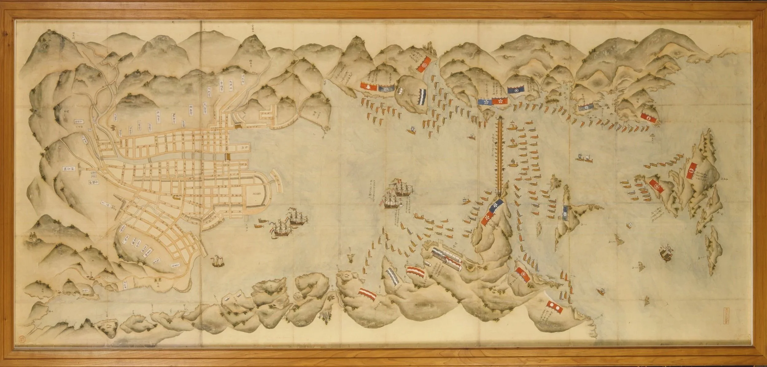
Map of Nagasaki
Ink and colours on paper, mounted in a wooden frame
Japan - Edo period (1615-1868), 17th century, 6th August in the Shōhō year (1647)
H. 101 cm L. 216 cm (including frame)
Ref. 8237
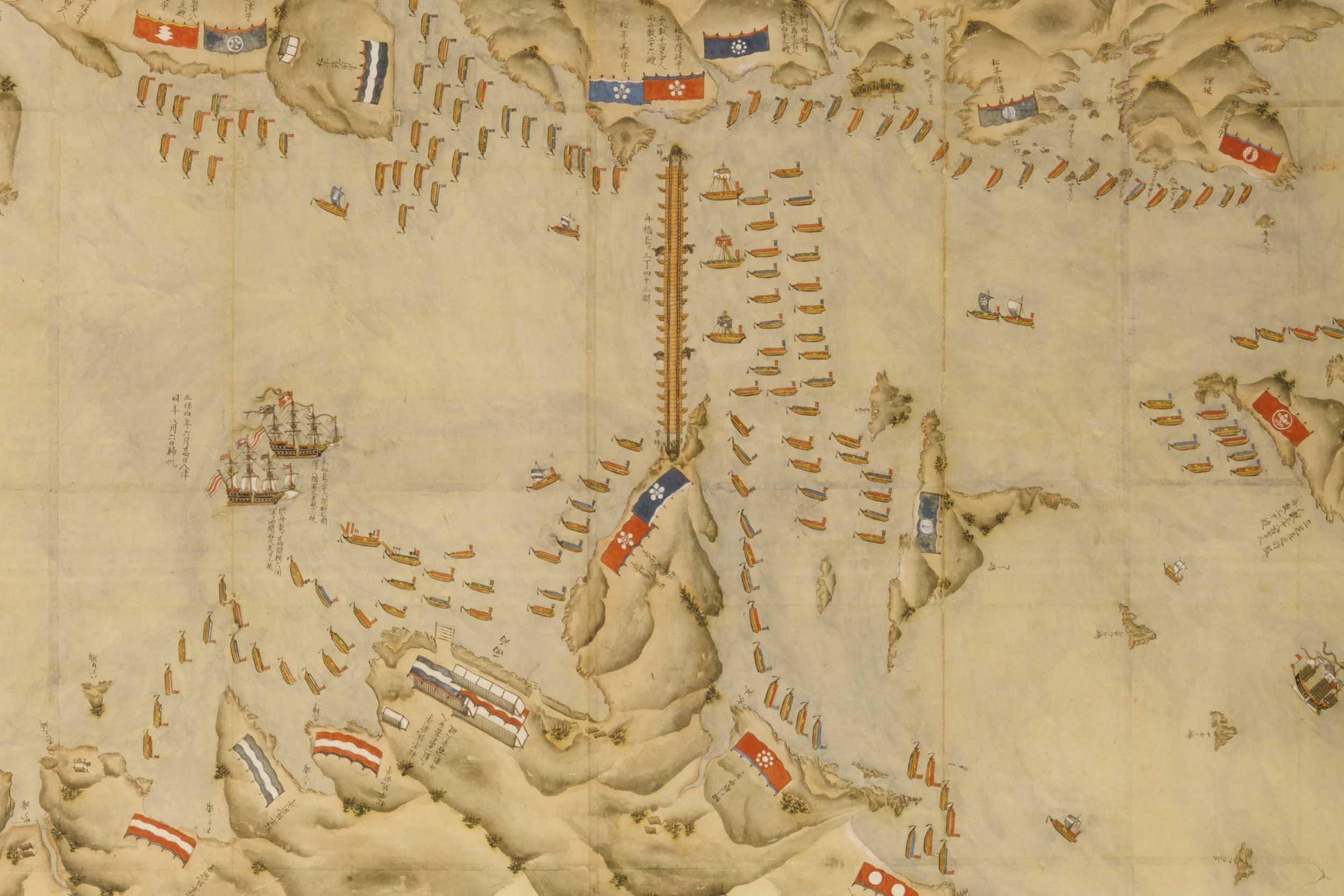
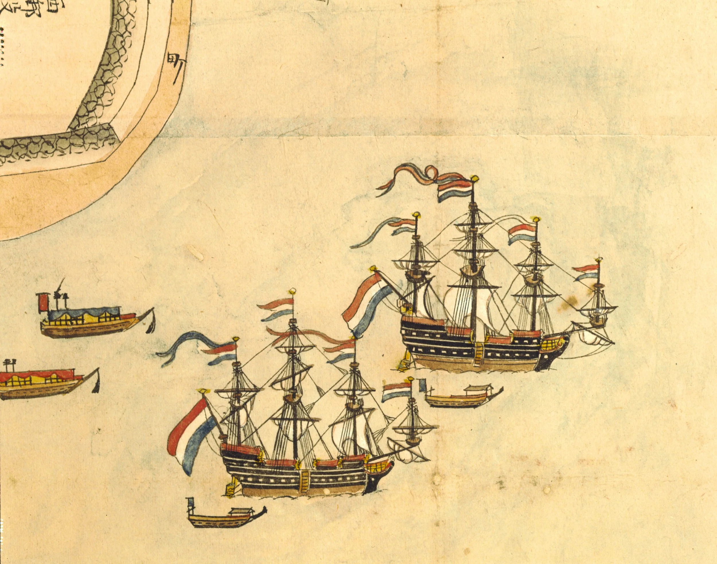
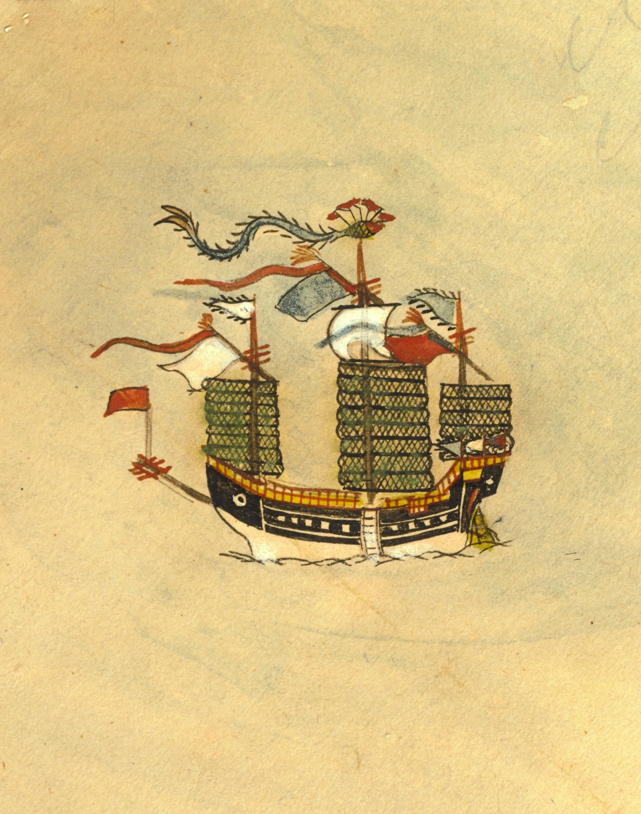
This large rectangular map, painted in ink with a restrained palette of blue, red, brown, green and white, vividly records a dramatic maritime confrontation in Nagasaki harbour: the blockade of two heavily armed Portuguese galleons by a bridge of boats, encircled by dense flotillas of Japanese vessels and the forces of local daimyō assembled on shore. The city’s streets, rivers, surrounding hills and the island of Deshima are rendered in panoramic detail. The Portuguese ships, flying white crosses on red flags, bear lengthy inscriptions noting their arrival on 14 June and departure on 6 August in the Shōhō year, as well as their dimensions and armaments, including stone-fire cannons. Three Dutch ships lie at anchor off Deshima, and a Chinese vessel departs at right. Daimyō named include Ōmura Tangomori, Ogasawara Shinanomori, Takariki Settsumori and Matsudaira Chikuzenmori. Red seals identify the map with the private library of Kurokawa Mamichi (1866-1925) and the name Kurokawa Mayori (1829-1906), his father.
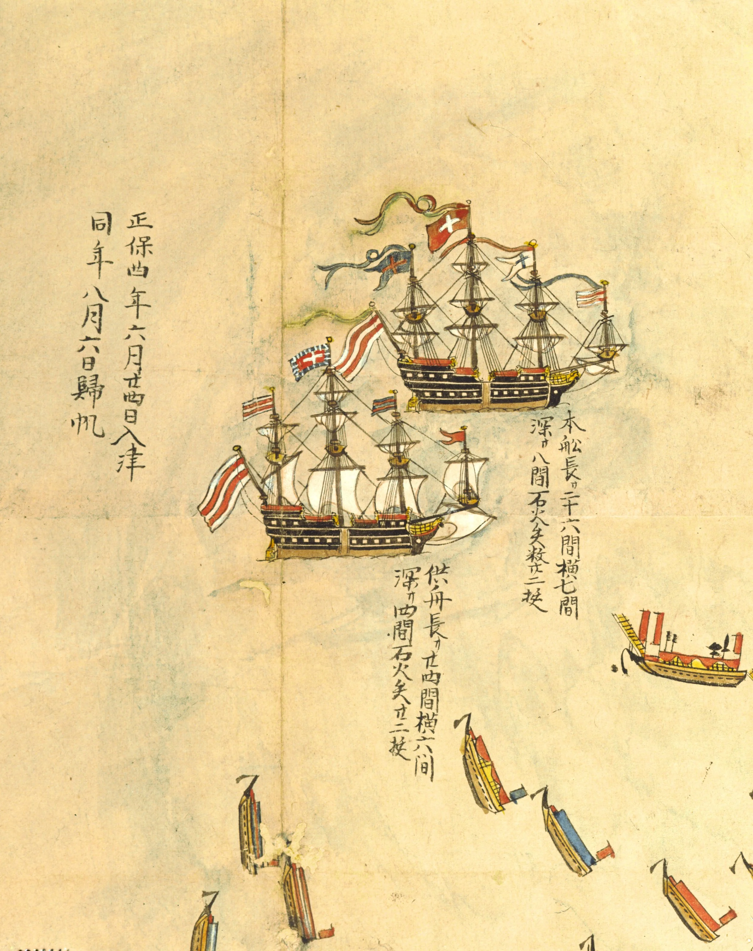
The map’s principal subject is the second Portuguese attempt to restore lucrative trading relations with Japan, then monopolised by the Dutch and Chinese. In 1647 an embassy sent by King João IV arrived off Nagasaki, marking the first formally accredited European mission to Japan. The voyage, long and hazardous, followed Portugal’s restoration of independence from Spain and involved repeated delays, storms and Dutch attacks before the fleet finally reached Japanese waters in July 1647.
Forewarned by the Dutch at Deshima, the Japanese authorities mobilised the Kyūshū daimyō and strengthened coastal defences. Although initial preparations were relaxed after earlier setbacks to the Portuguese fleet, the sudden arrival of the galleons prompted renewed alarm. Negotiations followed: the Portuguese refused to surrender their arms but agreed to lower their Christian flags. Meanwhile, over 50,000 troops gathered around Nagasaki, causing widespread panic.
While awaiting a decision from Edo, the authorities sealed the harbour with a vast pontoon bridge of some 300 boats, guarded by hundreds of vessels and thousands of soldiers. The shogunate ultimately refused the Portuguese request but permitted their peaceful departure. The failed embassy was widely recorded in Portuguese, Japanese and Dutch accounts, and commemorated in contemporary maps such as this example.
Provenance:
Kurokawa Mayori (1829-1906); thence by descent to his son Kurokawa Mamichi (1866-1925)
Published in:
Jorge Welsh (ed.), 2008, no. 14, pp. 180-87.
Martins and Curvelo (eds.), 2010, no. 54, pp. 204-08.
Morena (ed.), 2012, il. 43, pp. 340-41.
Weston (ed.), 2013, pl. 23, p. 75 (detail) and p. 110.
Curvelo and Pinto (eds.), 2018, pp. 86-87.
Ramos, vol. 35, March 2021, pp. 59-90 .
The Map of Nagasaki is published in After the Barbarians II. Namban Works of Art for the Japanese, Portuguese and Dutch Markets / Depois dos Bárbaros II. Arte Namban para os Mercados Japonês, Português e Holandês, edited by Jorge Welsh.
The exhibition catalogue includes contributions by Pedro Cancela de Abreu, Alexandra Curvelo, Christiaan J. A. Jörg and Miho Kitagawa (London/Lisbon: Jorge Welsh Books, 2008), pp. 180–187, cat. 14.
Catalogue available for purchase at the galleries and at the TEFAF stand.
To purchase online, please fill in our contact form or email books@jorgewelsh.com